Volcán de Fuego – Guatemala’s Fire Volcano
A Complete Professional Overview
With Key Facts & Sources
Introduction
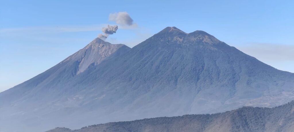
Volcán de Fuego (Spanish for “Volcano of Fire”, also known in Kaqchikel as Chi Q’aq’ meaning “where the fire is”) is one of the most active and studied volcanoes in Central America. It dominates the skyline near Antigua Guatemala and continues to shape the environment, hazards, and lives of Guatemalans.
👉 Source link: Volcán de Fuego – Wikipedia (English)
https://en.wikipedia.org/wiki/Volc%C3%A1n_de_Fuego
Geographic Location
- Location: Southern Guatemala
- Departments: Chimaltenango, Escuintla, Sacatepéquez
- Nearest city: ~16 km west of Antigua Guatemala
- Mountain range: Sierra Madre
- Coordinates: ~14.47° N, 90.88° W
Volcán de Fuego is part of a volcanic complex that includes Acatenango, and this ensemble is commonly referred to as La Horqueta.
Physical Characteristics
📍 Elevation: approx. 3,768 meters (12,360 feet) above sea level
📍 Volcano Type: Active stratovolcano (layered volcano from repeated eruptions)
📍 Volcanic Arc: Part of the Central America Volcanic Arc, formed by subduction of the Cocos Plate beneath the Caribbean Plate.
Stratovolcanoes are known for steep profiles and explosive eruptions compared to shield volcanoes.
Why It Is Called “Volcano of Fire”
- The name Fuego reflects the volcano’s frequent activity, including glowing lava, explosions, ash emissions, and ongoing eruptive behavior.
- In the Maya language Kaqchikel, Chi Q’aq’ means “where the fire is,” emphasizing its fiery nature historically.
Eruptive Activity
Volcán de Fuego is one of Guatemala’s most active volcanoes, with activity recorded for hundreds of years.
Frequent Activity
- The volcano typically shows low-level eruptions nearly continuously, with small explosions of gas and ash occurring fairly often.
- Larger eruptions that produce significant ash clouds, pyroclastic flows, and evacuations are less frequent but very hazardous.
Recent and Notable Eruptions
• 2018 Eruption:
- On June 3, 2018, Fuego produced one of its most powerful eruptions in decades.
- This event generated fast, deadly pyroclastic flows that buried several villages, killing over 200 people, with hundreds missing or injured.
- Thousands were affected and displaced.
• Ongoing Activity:
- Eruptions were reported in 2021, 2022, 2023, and 2025, with ash plumes, evacuations, and local disruptions.
- In June 2025, the volcano erupted again, prompting evacuations and closures of schools and roads due to ash and hazards.
These events highlight the volcano’s continued hazard potential and importance for monitoring.
👉 News source about recent eruption (June 2025):
https://apnews.com/article/e8bce196419a5f1dc0e15a48078c4228
Hazards and Risks
Volcán de Fuego poses several major natural hazards, especially during eruptions:
❗ Pyroclastic Flows
These are rapid avalanches of hot gas, ash, and volcanic rock that can travel down the volcano’s slopes at extreme speedand with great heat. They are the leading cause of fatalities in major eruptions, including 2018.
❗ Ash Clouds
Volcanic ash can rise high into the atmosphere, affecting air travel, air quality, and agriculture downwind of the volcano.
❗ Lahars (Volcanic Mudflows)
After heavy rain or eruptive activity, loose volcanic material can mix with water and form powerful mudflows that destroy infrastructure and bury settlements.
❗ Lava Flows
Lava can flow down the steep flanks, threatening homes and communities near the volcano.
Because of these hazards, evacuations and emergency planning are critical in communities close to the volcano.
Historical Timeline
Volcán de Fuego has a long eruptive history:
📌 Recorded eruptions back to the 1500s and earlier.
📌 Major documented eruptions include 1524, 1581–1582, 1705, 1880, 1932, 1974, and the 2018 event.
📌 The volcano entered a period of heightened activity beginning in 2002, with frequent explosive episodes.
These long trends are studied by volcanologists to better understand future behavior.
Volcanology & Monitoring
INSIVUMEH (the National Institute of Seismology, Volcanology, Meteorology, and Hydrology in Guatemala) along with other scientific groups closely monitor Fuego for seismic activity, gas emissions, ash plumes, and changes in behavior to help issue warnings and protect communities.
Human and Economic Impact
• Loss of life and destruction: The 2018 eruption was devastating for nearby populations and remains one of the deadliest volcanic events in recent Central American history.
• Evacuations: Periodic eruptions often require evacuation of families and closure of local infrastructure.
• Agriculture & health: Ashfall affects crops, water sources, and breathing conditions for people and livestock.
Tourism and Accessibility
Climbing Volcán de Fuego itself is generally not recommended or permitted because of its frequent activity and danger. Instead:
✔ Many tourists choose to hike Volcán Acatenango, a neighboring peak, for safety and views of Fuego’s eruptionsfrom a distance.
Key Facts at a Glance
| Feature | Details |
|---|---|
| Name | Volcán de Fuego (“Volcano of Fire”) |
| Also Known As | Chi Q’aq’ (Kaqchikel: “where the fire is”) |
| Location | Guatemala (Chimaltenango, Escuintla, Sacatepéquez) |
| Elevation | Approx. 3,768 m (12,360 ft) |
| Type | Active Stratovolcano |
| Activity Status | Very active with frequent eruptions |
| Most Dangerous Hazards | Pyroclastic flows, ash clouds, lahars |
| Historic Major Eruption | June 3, 2018 (devastating event) |
Further Reading & Source Links
- Wikipedia: Volcán de Fuego – https://en.wikipedia.org/wiki/Volc%C3%A1n_de_Fuego
- Wikipedia (Spanish): Erupción del Volcán de Fuego de 2018 – https://es.wikipedia.org/wiki/Erupci%C3%B3n_del_volc%C3%A1n_de_Fuego_de_2018
- Volcanoes & Eruptions Info – https://www.volcanoes.de/2025/02/07/volcan-de-fuego-in-guatemala/
- AP News (2025 eruption updates): https://apnews.com/article/e8bce196419a5f1dc0e15a48078c4228