Acatenango Volcano – Guatemala’s Great Stratovolcano
Professional Article in English with Key Facts & Links
Introduction
Acatenango is one of Guatemala’s most striking and imposing volcanoes. It is part of the Sierra Madre volcanic range, located near Antigua Guatemala, and is widely known for its majestic views, extensive climbing routes, and geological significance.
👉 Source (Encyclopedic): Acatenango – Wikipedia (English)
https://en.wikipedia.org/wiki/Acatenango
Location & Geography
- Country: Guatemala
- Departments: Chimaltenango and Sacatepéquez
- Near Cities/Towns: Acatenango, Antigua Guatemala, San Miguel Dueñas
- Mountain Range: Sierra Madre
- Coordinates: ~14.50° N, -90.89° W
Acatenango stands tall in the Central American Volcanic Arc, a chain of volcanoes formed by tectonic plate subduction along the Pacific coast.
Physical Profile – Height & Peaks
👉 Elevation: Approx. 3,976 meters (13,044 ft) above sea level, making it the third-highest volcano in Guatemala and one of the tallest in Central America.
Acatenango has two main peaks:
- Pico Mayor (the highest summit at ~3,976 m)
- Yepocapa (also called Tres Hermanas / Three Sisters, ~3,880 m)
This dual-peak structure gives climbers two distinct summits to explore.
Volcanic Complex & Brothers
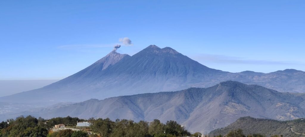
Acatenango is physically connected to its famous neighbor Volcán de Fuego, forming a volcanic massif known locally as “La Horqueta.”
- Fuego means “fire” and is one of the most active volcanoes in the world.
- Acatenango is considered its “twin” or older sibling — larger and taller but dormant.
This volcanic pairing is both geologically significant and popular for climbers who want dramatic views of Fuego’s eruptions from a safer distance.
Volcanic Activity
Acatenango is currently classified as dormant, which means it shows no regular eruptive behavior.
Historical Eruptions
Confirmed historical eruptions are rare, but documented activity includes:
- 1924 – 1927: Minor phreatic (steam) explosions on the volcano’s flank.
- December 1972: Small phreatic explosion producing airborne volcanic rocks (“volcanic bombs”) and ash reaching nearby towns.
Before this, Acatenango had many prehistoric explosive episodes over tens of thousands of years. These ancient eruptions produced widespread lava flows and pyroclastic deposits.
No recent eruptions have occurred since 1972, and volcanic monitoring shows only occasional fumarolic gas release and minor seismic activity.
Geological History
- The volcano’s volcanic activity began around 200,000 years ago and has continued (on and off) throughout geological history.
- The volcanic chain that includes Acatenango and Fuego is the result of the Cocos Plate subducting beneath the Caribbean Plate — a process that fuels volcanic activity across Central America.
Over time, older eruptive centers have collapsed and formed huge debris avalanches extending dozens of kilometers from the volcano.
Climbing & Tourism
Acatenango is one of Guatemala’s most popular volcano hikes, known for being challenging:
Difficulty & Duration
- The trek from the base to the camping area typically takes 5–9 hours depending on fitness level.
- Reaching the summit or highest peak can take an additional 1 hour from base camp.
- The hike is strenuous due to steep slopes, volcanic sand, and altitude gain.
Best Experiences
Many hikers choose to camp overnight near the summit, which offers spectacular panoramic views and the chance to witness sunrise above the clouds.
Fuego Views
One of the main attractions is the ability to watch Volcán de Fuego’s eruptions from a safe vantage point on Acatenango’s summit or ridge. This makes the climb a unique combined experience — observing an active volcano while climbing a dormant one.
Flora & Landscape
- Hikers ascend through pine forests, cloud forests, and high-altitude ecosystems along the trail.
- The slopes also include agricultural land with crops such as maize and beans before the forest zone begins.
Cultural & Local Aspects
- The volcano’s name Acatenango comes from Nahuatl, meaning roughly “place with walled reeds” or “walled place.”
- Local legends and indigenous history link it with neighboring volcanoes, contributing to rich cultural narratives about the land.
- Nearby villages like La Soledad are traditional starting points for guided hikes.
Key Facts at a Glance
| Feature | Detail |
|---|---|
| Name | Acatenango |
| Height | ~3,976 m (13,044 ft) |
| Type | Stratovolcano (Dormant) |
| Location | Chimaltenango & Sacatepéquez, Guatemala |
| Volcanic Complex | Part of La Horqueta with Volcán de Fuego |
| Last Eruption | 1972 (phreatic) |
| Best Known For | Hiking and views of Fuego eruptions |
| Climbing Difficulty | Difficult / strenuous |
Further Resources & Reading
📘 Reliable Information Sources
- Wikipedia (English): Acatenango – https://en.wikipedia.org/wiki/Acatenango
- Volcanes de Guatemala: Volcán de Acatenango details – https://www.volcanesdeguatemala.com/volcan-de-acatenango
- Geological hazards analysis: Dr. John Seach’s VolcanoLive – https://volcanolive.com/acatenango.html