
Volcán de Agua – Guatemala’s Majestic Stratovolcano
Comprehensive Article in English with Sources & Links
Overview
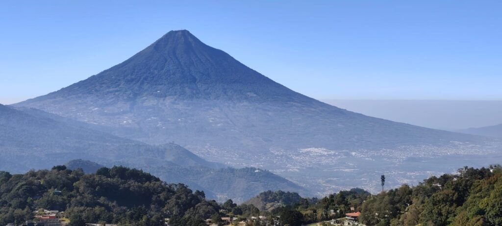
Volcán de Agua (literally “Volcano of Water”) is a large stratovolcano in south-central Guatemala, known for its striking symmetrical cone and dramatic influence on the region’s geography and history. It is one of the most iconic natural landmarks visible from the historic city of Antigua Guatemala.
👉 Official Wikipedia page: https://en.wikipedia.org/wiki/Volc%C3%A1n_de_Agua
Location and Geography
- Country: Guatemala 🇬🇹
- Departments: Sacatepéquez and Escuintla
- Proximity to major cities: Approximately 5–10 km south of Antigua Guatemala and ~20 km from Escuintla.
- Coordinates: approx. 14.465° N, -90.743° W
The volcano rises dramatically above the surrounding terrain with its peak at about 3,760 meters (12,336 ft) above sea level. The lower slopes are fertile and widely planted with coffee and crops, while the upper slopes are covered in forests and grasslands.
Name and Cultural Significance
- The Kaqchikel Maya historically called this volcano Hunahpú (linked to the sacred Mayan figure Hunahpú from the Popol Vuh myth).
- The modern name “Volcán de Agua” (Water Volcano) comes from a catastrophic lahar (mudflow) in 1541 that destroyed Guatemala’s early Spanish capital and gave the volcano its legacy-defining story.
Geological Profile
Volcán de Agua is a stratovolcano, formed by many layers of volcanic rock, ash, and minerals from eruptions that occurred thousands of years ago. Despite its symmetrical cone and volcanic structure:
Eruption Status
- There are no confirmed historical eruptions of Agua in written history.
- Its volcanic activity likely predates the last 10,000 years, making it classified as dormant or extinct by modern volcanology.
Hazards
Even without eruptions, Agua poses non-eruptive hazards, especially lahars and debris flows triggered by intense rainfall or earthquakes. These hazards remain a serious concern because of the volcano’s steep slopes and proximity to populated areas.
Historical Event: The 1541 Disaster
One of the most significant moments in Agua’s recorded history occurred on September 10–11, 1541:
- After several days of heavy rain, a massive debris flow (often described as a lahar) surged down the volcano’s flank.
- This event destroyed Ciudad Vieja, the Spanish colonial capital at the time, and killed hundreds of inhabitants.
- Following this disaster, the capital was relocated to Antigua Guatemala.
This catastrophe is the cornerstone of Agua’s modern name and its cultural memory in Guatemala.
Climbing and Tourism
Volcán de Agua is a popular but demanding hike:
- The most common starting point is Santa María de Jesús, a village on the volcano’s northern slopes.
- Climbers gain about 1,700 m in elevation and should be well-prepared with physical endurance, supplies, and sometimes local guides.
- On clear days, hikers can enjoy panoramic views including Lake Atitlán and the surrounding volcanic landscape.
Environmental & Protected Area Status
The volcano and its surrounding terrain have been designated a protected area since 1956, preserving both its ecological diversity and natural beauty.
Key Data at a Glance
| Feature | Detail |
|---|---|
| Name | Volcán de Agua |
| Elevation | ~3,760 m / 12,336 ft |
| Volcano Type | Stratovolcano |
| Activity Status | Dormant / Extinct |
| Last Known Significant Event | 1541 lahar |
| Cultural Name | Hunahpú (Maya) |
| Nearest Major City | Antigua Guatemala |
Further Reading & Sources
- Wikipedia – Volcán de Agua (English): https://en.wikipedia.org/wiki/Volc%C3%A1n_de_Agua
- Dr. John Seach – Volcano details: https://volcanolive.com/agua.html
- VolcanoDiscovery – Geological info: https://www.volcanodiscovery.com/agua.html
- PeakVisor – Geographic overview: https://peakvisor.com/peak/volcan-de-agua.html
- Volcanes de Guatemala (Spanish site): https://www.volcanesdeguatemala.com/volcan-de-agua
📍 Interactive Hiking Route Resources & Maps
These sites let you visualize and download trail maps, profiles, and GPS data for climbing Volcán de Agua:
🔗 Trail overview with photos, difficulty & map
• Volcán de Agua route (near Santa María de Jesús) on AllTrails — includes a trail map, elevation profile, photos, distance (~16.3 km) and estimated time (8.5–9.5 h). Volcán de Agua trail map on AllTrails (hard, detailed route info)
🔗 Downloadable GPS tracks & trail PDFs
• Marathon Volcán Agua (running/hiking course, customizable PDF & GPX files) — you can download the route map in PDF and use the GPS track on hiking apps/GPS devices. Ultra Trail Guatemala Volcán Agua route (PDF & GPX)
🔗 Community-shared GPS hiking routes
• Volcán de Agua trail on Wikiloc — you can view the trail course and download GPS files compatible with hiking apps. Volcán de Agua hiking trail (Wikiloc)
• Santa María de Jesús to summit route on Wikiloc — includes GPX download and trail details like elevation change. Volcán de Agua (Ruta Santa María de Jesús) – Wikiloc
🔗 Alternative route beginning near Ciudad Vieja
• Volcán de Agua (Ruta de Ciudad Vieja) trail — another climbing path with similar map data available to download and use on GPS apps. Volcán de Agua trail (Ciudad Vieja) – GPS map
🧭 Tips for Using These Maps
✅ Use a smartphone hiking app (AllTrails, Wikiloc, Komoot) to import GPX files and follow routes offline.
✅ Print the PDF or screenshots before you go, since mobile signal can be weak on the volcano.
✅ Combine GPS maps with good physical trail markers — most Volcán de Agua routes are not highly marked on the ground. — Encourage safety and awareness near trail intersections.